Maroochydore Coastal Hazard Adaptation Precinct Planning - Investigation
Sunshine Coast Council is investigating coastal hazard adaptation at Maroochydore.
Sunshine Coast Council is investigating coastal resilience at Maroochydore.
We are looking at ways to help protect Maroochydore and reduce the risk of coastal hazards and flooding now and into the future.
Proactive measures taken today will ensure that we are better equipped to face future climate challenges, minimise damage and ensure a more resilient Sunshine Coast for everyone.
Protecting the local values and character across the region are critical criteria in ensuring our region stays great for future generations. These investigations will include identifying adaptation options, with a primary focus on long-term solutions for future planning out to the year 2100.
Find out more on some of the approaches we will investigate at Maroochydore in Information Sheet: Coastal Hazard Adaptation Precinct Planning Investigation - Maroochydore.
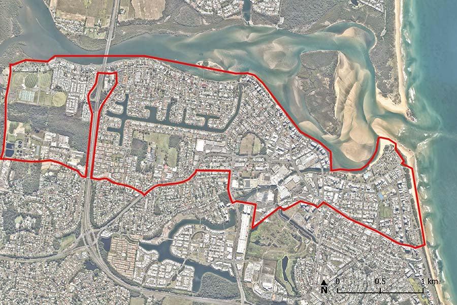
Investigation area
The Maroochydore investigation will explore what adaptation options could work in this area which extends from the Maroochy River along Bradman Avenue from Cod Hole Park to Cotton Tree, including about 500 metres landward.
Funding
The Mooloolaba and Maroochydore CHAPP investigations received grant funding from the Australian Government.
Community engagement opportunities
We value our community’s knowledge and input into these investigations. There will be multiple opportunities for our community and key stakeholders to be involved throughout the project.
Protecting the local values and character at Maroochydore are critical criteria that will be considered as we assess possible mitigation options.
We invited the community to provide input on coastal spaces, how you use them, their value, and how they might be adapted against coastal hazards and flooding. Input will be considered in the development and analysis of options. Consultation was open from Monday 28 October to Monday 25 November 2024.
Timeline for investigations
- 28 October 2024: Consultation opens. Have your say on the way you use and value coastal areas, and how Council might adapt them against coastal hazards
- 25 November 2024: Consultation closes.
- 21 March 2025: Close the loop. We provided our community with an update on the outcomes of the consultation process.
- 2025 onwards: Investigation and options analysis. Feedback from the community will be reviewed and considered in the development of adaptation options.
Frequently asked questions
What is Council's role in managing coastal hazards?
What is Council's role in managing coastal hazards?
While Council plays a key role in managing coastal hazards, the effective management of these hazards requires a collaborative approach. Working together will become even more important as we respond to the hazards of a changing climate. Proactive measures taken today will ensure that we are better equipped to face future challenges, minimise damage and ensure a more resilient Sunshine Coast for everyone. To find out more information about a collaborative approach to successful adaptation please see Fact Sheet 3 – Working together.
How will the values and character of the area be retained when considering adaptation options?
How will the values and character of the area be retained when considering adaptation options?
Adaptation approaches seek to safeguard the values (social, environmental and economic) and character of the region. The coastal lifestyle that is critical to the identity of the Sunshine Coast is defined by the local values and character of our coastal places. We need your input on how you currently use these places and what you value about them. Your input will be considered in the development and analysis of potential adaptation solutions.
What kind of adaptation options will be considered to manage impacts from coastal hazards?
What kind of adaptation options will be considered to manage impacts from coastal hazards?
Reducing coastal hazard and flood risks is complex due to the dynamic nature of the coastal environment and the way we use the coast. This complexity means that no single adaptation element can effectively reduce the risks from flooding and coastal hazards. It will require multiple targeted and integrated actions that can evolve and change with our needs over time. Options will need to be developed by considering the specific challenges and unique nature of each location. To find out more about adaptation elements please see Fact Sheet 2- Adaptation to manage impacts from coastal hazards.
What are coastal hazards?
What are coastal hazards?
Erosion and inundation are natural processes that shape the coastline. However, they can become hazards when they impact on coastal values and how we use and enjoy the coast. Coastal hazard exposure is expected to increase with changes in wave action, storm activity and sea level rise associated with climate change. Coastal hazards include inundation of low-lying coastal areas and erosion of the shoreline. In Southeast Queensland, significant coastal hazard impacts are typically associated with East Coast Lows and tropical cyclones. To find out more about coastal hazards please see Fact Sheet 1 - Common coastal hazard adaptation and flooding terminology.
How are Coastal Hazard adaptation investigation areas determined?
How are Coastal Hazard adaptation investigation areas determined?
Investigation areas are determined by Council's endorsed Coastal Hazard Adaptation Strategy (CHAS). The Coastal Hazard Adaptation Strategy assigned an adaptation response and pathway for each locality across the Sunshine Coast. Adaptation responses and options are considered by locality which is based on four zones and 28 associated beach units.
When will Council be undertaking investigations in my area?
When will Council be undertaking investigations in my area?
Investigations are currently underway in Golden Beach and Caloundra (Bulcock Beach), Maroochydore and Mooloolaba. These areas are already experiencing the impacts of coastal hazards, including inundation. Familiarise yourself with the adaptation pathway outlined for your local beach or area by visiting the endorsed Coastal Hazard Adaptation Strategy (CHAS).
What is a Coastal Hazard Adaptation Precinct Planning Investigation?
What is a Coastal Hazard Adaptation Precinct Planning Investigation?
Coastal Hazard Adaptation Precinct Planning investigations will identify and assess potential adaptation options to reduce the impacts to our community and environment caused by coastal hazards and flooding.
Contact us
You can ask a question or share feedback about coastal hazards and Council’s coastal planning activities by emailing [email protected]
You can also register for regular updates which will include invitations to a range of opportunities to have your say and provide feedback to Council via Have Your Say Sunshine Coast.