Sunshine Coast Blue Heart
Council would like to provide some clarifying information for our community about the Blue Heart, including the need for this project, flood insurance and landowners’ use rights.
The aims of the Blue Heart project
Council is planning ahead for future challenges such as increased rainfall, flooding and permanent sea level rise. In doing so, council is taking action now to help manage the risk to people, assets and services associated with climate change and severe weather events.
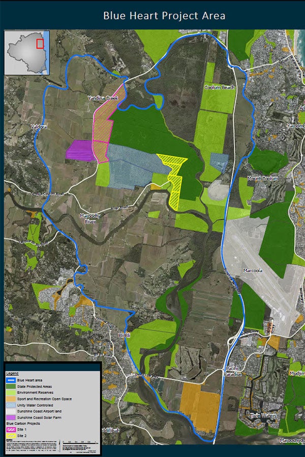
The Blue Heart is approximately 5,000 hectares in size and takes in a large area of natural floodplain and some small areas of residual land in the lower Maroochy River catchment.
Blue Heart partners (Sunshine Coast Council, the State Government and Unitywater) are working to:
- protect the most critical areas of the floodplain
- establish wetland and floodplain ecosystems
- improve water quality in the Maroochy River
- provide community and recreation opportunities
- investigate and support new uses for the surrounding rural and agricultural lands, including economic opportunities for landowners.
This includes investigations into blue carbon farming, which involves sequestering carbon in mangroves and salt marshes. This could become an alternative source of income for Blue Heart landholders in the future, should they wish to pursue this opportunity. Participation by private landowners in any blue carbon farming projects is always entirely voluntary and a decision for the individual landowner.
History of the Blue Heart area
History of the Blue Heart area
The Maroochy River floodplain was once predominantly a sugar cane growing hub and an important contributor to the region’s economy.
After the Moreton Sugar Mill in Nambour closed in 2003, areas of sugar cane farming on the flood plain declined. Landholders have responded to this in a variety of ways. Some have investigated alternative income sources; some have continued agricultural uses; while others have sold their properties.
Since 2016, council has strategically acquired some former farmland for the purpose of rehabilitation, conservation, recreation and to trial new land uses on those properties, compatible with the transitioning floodplain. Unitywater purchased some land in the Maroochy River floodplain for the purpose of nutrient offsets and to improve water quality in the Maroochy River. The Department of Environment, Science and Innovation also own land in the area for conservation purposes.
In 2019 council, the Queensland Department of Environment, Science and Innovation and Unitywater became Blue Heart project partners. They are proactively working together to achieve the project’s objectives.
Existing landowners in this area are under no obligation or compulsion to participate in this project.
What are Blue Heart partners doing now to achieve the project’s objectives?
What are Blue Heart partners doing now to achieve the project’s objectives?
A list of current projects includes:
- managing the conservation reserve network, including the Queensland Government Coolum Creek Conservation Park and the Coolum Creek Environment Reserve
- managing the Yandina Creek Wetland to remove nutrients and sediments from the river, which contributes to water quality and overall health improvements of the Maroochy River
- managing weeds and feral animals
- managing nature-based recreation and ecotourism opportunities, including the Maroochy Wetland Sanctuary, Yandina Creek Wetland and existing recreation trails while planning for potential future recreation trails
- environmental education through the Maroochy Wetlands Sanctuary Visitor Information Centre and community events to raise awareness of wetland ecosystems
- managing the Sunshine Coast Solar Farm, which offsets council’s electricity costs across all facilities and operations
- partnering with leading experts in Australia in a series of research and monitoring programs underway including soil chemistry, surface and groundwater dynamics, marine plants, carbon stocks and sequestration, greenhouse gas emissions, biodiversity and threatened species (including fish and water mouse), fish habitat values and environmental co-benefits
- planning for carbon ecosystem rehabilitation, including about 165 hectares of land purchased by Sunshine Coast Council through the Environment Levy as well as part of Unitywater’s Yandina Creek Wetland.
What are the rights of landowners in the Blue Heart project area to develop or subdivide their land and is the Blue Heart project preventing them from doing so?
What are the rights of landowners in the Blue Heart project area to develop or subdivide their land and is the Blue Heart project preventing them from doing so?
Under the Queensland Government’s South East Queensland (SEQ) Regional Plan 2023 and council’s Sunshine Coast Planning Scheme 2014, these properties cannot be developed for urban purposes or further sub-divided as they are located outside of what is termed the “Urban Footprint” in the SEQ Regional Plan 2023.
This reflects both the historic rural and non-urban use of this land as well as the presence of flood hazard across much of the Maroochy River catchment. The majority of properties are identified as being subject to high risk flooding. They are not suitable for urban development and individual lots cannot be subdivided below a minimum lot size of 100 hectares.
Specific limitations on the use and subdivision of the land at a regional planning level have existed since 2005, when the first ‘statutory’ SEQ Regional Plan was introduced and the original “Urban Footprint” regional land use category established. The limitations are not a consequence of the Blue Heart project and would continue to exist regardless of the Blue Heart project.
The Blue Heart project also does not change the existing tenure of land. Landholders within the Blue Heart can continue to use their land for activities that are permitted under the SEQ Regional Plan and the Sunshine Coast Planning Scheme 2014. Future conditions, including increased flooding and tidal inundation which are predicted to occur as a result of climate change (and not as a consequence of the Blue Heart project), may impact the viability of some of these activities over time.
Ecotourism and cultural tourism are a possible alternative land use in the Blue Heart as long as it is compatible with the transitioning floodplain. This is currently open to all landholders to investigate if it is consistent with the Sunshine Coast Planning Scheme. Interested landowners are encouraged to visit our planning and development search page.
Council is preparing a new planning scheme that will replace the current Sunshine Coast Planning Scheme 2014. In December 2023, council submitted the draft new planning scheme to the State Government for State interests review. Subject to State government and council approval, the draft new planning scheme will be placed on public display.
Future community engagement activities will provide opportunities for our community to provide feedback on the draft new planning scheme. All feedback will be considered before any decision is made to adopt the new planning scheme.
Register to receive project updates and be notified about the timing of future community engagement activities.
Find out more information about the new planning scheme project.
What is the timeline for climate-driven changes in the floodplain?
What is the timeline for climate-driven changes in the floodplain?
The Blue Heart project is proactively planning for future climate-driven challenges in the lower Maroochy River catchment area. As part of this planning, council’s Coastal Hazard Adaptation Strategy (CHAS) was prepared to better understand and manage the impacts of coastal hazards on our communities, our environment and the liveability of our region.
For the Maroochy River floodplain, the adaptation response for this area in the CHAS identifies the need to develop a special area adaptation plan for the long-term transition of inundation prone agricultural areas to wetland ecosystem services. This transition will continue to occur from now to beyond 2100 and associated planning in partnership with stakeholders is an ongoing activity.
The introduction of tidal waters onto council owned land as part of a blue carbon trial project will provide insights now into how long-term climate-driven changes may affect land in the Blue Heart and the potential economic, social and environmental benefits.
Flood risk and insurance
Flood risk and insurance
Landowners have raised concerns their flood insurance has increased as a result of being located in the defined Blue Heart project area.
Despite what some insurance companies may have indicated, the Blue Heart project is not the cause of insurance premium increases, nor are these increases isolated to just Blue Heart landowners.
Following the 2010-2011 floods, the Queensland Flood Commission of Inquiry recommended that local governments provide risk-based mapping so residents, professionals and local government can more clearly understand, prepare for and manage flood risk. As a result, Sunshine Coast Council updated its flood mapping information in 2021 for the whole region.
Flood mapping does not create more risk on a property. It simply provides information that enables people to understand the existing and future risk. This risk exists for the properties in this area regardless of the Blue Heart project.
Flood risk information is also used by insurance companies to determine premiums. Many insurance companies also develop their own flood modelling - which may or may not rely on council’s published flood mapping – to inform the price of their premiums.
Many landowners across the nation have experienced increased flood insurance premiums over the past 12 months, driven as a result of more accurate flood impact information. The Insurance Council of Australia also gave evidence to the recent insurance inquiry, that premium increases have been driven by the impact of flood events, building and repair cost inflation, and the cost of reinsurance.
The 2022 floods in south east Queensland led to almost $6 billion in insurance claims, resulting in very significant increases in insurances, and particularly impacting those properties located in floodplains as insurance companies seek to de-risk from those areas.
If any property owner is dissatisfied with their quoted insurance premium, they should raise this with their insurer and/or consider other potential insurers.
More information can be found on our Flooding questions and factsheets page, the State Flood Insurance advice and Insurance Council Advice.
Do property owners in the Blue Heart have to sell their land?
Do property owners in the Blue Heart have to sell their land?
No. Property owners are not forced to sell their land to council.
Where council does purchase land, it is through a formal negotiated contract process which includes a mutually agreed price that is informed by independent market valuations.
If farmers in the Blue Heart project area wish to remain farming, they can continue to do so.
Land in the Blue Heart area which council owns will remain in public ownership. It will be used to support achieving the Blue Heart project objectives including for protection of flood storage, conservation, public accesses, trails, parkland, open space areas for our community and will be subject to further planning.
Council cannot inundate lands it does not have control of, and the Blue Carbon Project being delivered as part of the Blue Heart has been designed to ensure this does not occur.
Extensive hydrological modelling has been completed and engineers have confirmed there is no risk to neighbours, other than the already existing flooding and inundation risk that will occur as a result of tidal inundation and climate change.
The Blue Heart project is part of council’s strategic directions for a sustainable Sunshine Coast and is recognised and reflected in documents including the Environment and Liveability Strategy and Coastal Hazard Adaptation Strategy, which both went through comprehensive and formal community consultation before they were tabled for discussion and adopted by council.
The Blue Heart project is also a strategic direction in council’s Corporate and Operational Plans, which were also endorsed at council meetings. It is a core project of the annual Environment Levy Program and council has considered and supported a number of Environment Levy land acquisitions located in the Blue Heart.
How are Blue Heart residents engaged by council?
How are Blue Heart residents engaged by council?
The Blue Heart project is part of council’s strategic directions for a sustainable Sunshine Coast and is recognised and reflected in documents including the Environment and Liveability Strategy and Coastal Hazard Adaptation Strategy, which both went through comprehensive and formal community consultation before they were tabled for discussion and adopted by council.
The Blue Heart project is also a strategic direction in council’s Corporate and Operational Plans, which were also endorsed at council meetings. It is a core project of the annual Sunshine Coast Environment Levy Program and council has considered and supported a number of Environment Levy land acquisitions located in the Blue Heart.
Council has been engaging with landholders and residents in the Blue Heart as well as a variety of relevant groups and organisations. In 2021 four landholder drop-in information sessions were held.
In 2023 there were many engagement opportunities, ranging from guided tours of projects, information stalls at events, presentations and webinars. There were multiple face-to-face meetings with landholders.
In addition, and in response to enquiries, there was engagement via phone and email with a number of landholders in the Blue Heart as well as involvement of Traditional Owners, the Kabi Kabi peoples.
“The Blue Heart webpage has resources and links for landholders in the project area. Landholders and residents are invited to follow Blue Heart project progress by registering to receive Blue Heart email updates..
We also mail out information at times. You can also email the Blue Heart team at [email protected]
How will the land transition to estuarine wetlands?
How will the land transition to estuarine wetlands?
Most of the lower Maroochy River floodplain has been highly modified with the original freshwater wetlands drained and vegetation cleared for farming many years ago. Due to the predicted impacts of climate change, including more intense and frequent major flooding events and rising sea-levels, this area is expected to transition away from a predominantly active rural and large lot rural-residential landscape to a mixed rural and regenerative landscape with more extensive areas of estuarine habitat and ecosystems. This also means it is not possible to return these areas to freshwater wetlands.
The Blue Heart project provides for a collaborative response to manage the land and water through this transition to provide a variety of positive environmental, social and economic outcomes, including ongoing agricultural activities and opportunities for conservation, water quality nutrient and vegetation offsetting, carbon farming, recreation and ecotourism.
Research findings to date indicate that biodiversity habitat values recorded at Yandina Creek Wetland, where the process has already begun, are higher in comparison to Council-owned former farmland that has not yet been restored.
The publicly-owned project sites will now be managed for conservation values, which will involve allowing the site to rehabilitate with natural wetlands. We observed mangroves populating the adjacent Coolum Creek Environment Reserve soon after active clearing was stopped, and we expect a similar outcome at other sites.
How will community areas be created and used?
How will community areas be created and used?
One of the objectives of the Blue Heart is to provide community and recreation opportunities. Blue Heart-appropriate infrastructure such as canoe launches, walking trails and bird hides will create potential tourism opportunities. Potential public facilities such as trails, parkland, sport and recreation and open space areas for the community will be subject to further planning.
Potential public facilities such as accesses and trails, parkland, sport and recreation and open space areas for the community will be subject to further planning.
Council has received funding through the SEQ City Deal to support targeted land acquisitions and on-ground activities that could include recreation outcomes in the Blue Heart. Currently there is access to the Yandina Creek Wetlands, off River Road, and we are looking at opportunities to improve access to other public lands in the Blue Heart project area.
What type of research and data collection has been undertaken?
What type of research and data collection has been undertaken?
Council has partnered with leading experts in Australia to understand coastal hazards, wetland rehabilitation, carbon farming legislation and hydrology to deliver blue carbon ecosystem rehabilitation. The project is also underpinned by a partnership with researchers from four of Australia’s leading universities with expertise in coastal rehabilitation and blue carbon. A series of research and monitoring programs are underway to carefully monitor changes associated with rehabilitation efforts in the Blue Heart. These studies include soil chemistry, surface and groundwater dynamics, marine plants, carbon stocks and sequestration, greenhouse gas emissions, biodiversity and threatened species (including fish and water mouse), fish habitat values and environmental co-benefits. Research will be ongoing but has already indicated that some lands north of the river are naturally transitioning quickly to an estuarine wetland environment, with much higher biodiversity values than those lands that have not yet transitioned.
How was the Blue Heart boundary established?
How was the Blue Heart boundary established?
Council’s comprehensive flooding and coastal hazard mapping, was used to guide the development of the Blue Heart polygon which broadly reflects a heart-shaped area on the Maroochy floodplain affected by such hazards. The updated coastal tidal inundation mapping was prepared as part of the development of the Coastal Hazard Adaptation Strategy which was based on state Government requirements.
The Blue Heart polygon is not based on property boundaries but rather defines an area of focus for where council, partners and other project stakeholders can consider and respond to the identified flooding and coastal hazards.
What is blue carbon farming and how might it work in the Blue Heart?
What is blue carbon farming and how might it work in the Blue Heart?
Blue carbon is carbon stored in marine and coastal ecosystems, such as seagrasses, tidal marshes and mangroves. It includes carbon that is stored in the bodies of plants and animals as well as carbon in debris and soil. Coastal wetland restoration projects can be registered with the Australian Government and carbon credits can be secured. This is called blue carbon farming.
Blue carbon farming is a potentially compatible and alternative land use in the transitioning floodplain. Because carbon credits can be produced and traded, it may also be a potential form of income in the future. Council is trialling a blue carbon project on council-owned land to determine the feasibility of blue carbon farming and will share learnings with private landholders. The blue carbon trials are taking place on council-owned land between Yandina Coolum Road, River Road and Yandina Creek. Blue carbon farming may be of interest to some Blue Heart landholders who are wishing to explore alternative land use and incomes.
Blue carbon farming is relatively new in Australia. This is the first blue carbon project registered under the Clean Energy Regulator. That means there are no previous Australian blue carbon credits on the market. Given an important component of understanding the feasibility of blue carbon farming is the market price of blue carbon credits, it is likely to be several years before we have enough information to effectively assess the economic feasibility of this.
Council has registered council-owned land with the Australian Government’s Clean Energy Regulator under the Carbon Credits (Carbon Farming Initiative - Tidal Restoration of Blue Carbon Ecosystems) Methodology Determination 2022. This process involved reviewing and assessing the application and associated documents, which includes a Mosquito Management Plan and Hydrological Report.
Where do the funds from Blue Heart come from?
Where do the funds from Blue Heart come from?
Funds from council’s Environment Levy Program are used to strategically acquire and manage land for environmental purposes. Over the past five years, some blocks within the lower Maroochy floodplain have been acquired for this purpose.
The SEQ City Deal is a partnership between three levels of government to deliver projects, with the implementation plan for the partnership released in July last year. This included $35.3 million in funding for the Blue Heart project – of which $15 million is being contributed by the Queensland Government for land acquisitions and $5 million is being contributed from the Australian Government for other on ground-related activities.
In late 2023, 120 hectares of land was purchased by council at a cost of $6 million. The properties have been initially purchased with available council General Revenue, with council to be reimbursed from the Queensland Government component of the SEQ City Deal funding occur once the relevant funding agreements have been finalised and executed. This is expected in the next couple of months.
It is proposed the Australian Government’s $5 million in funding will be used for recreational elements (such as tracks or boardwalks) on public land within the Blue Heart, which could also support other council projects such as the Nambour to Coolum Trail.
No elements of these City Deal funded projects will infringe on property rights or establish any constraints on landholders.
In 2022, Blue Heart partners received an Australian Government’s Department of Climate Change, Energy, Environment and Water blue carbon ecosystem restoration grant of $2.036 million. Council-owned land in the vicinity of Yandina Coolum Road, River Road and Yandina Creek was identified as suitable for this trial on the local economic feasibility of Blue Carbon.
Will rehabilitation effect neighbouring properties?
Will rehabilitation effect neighbouring properties?
Consent is required if neighbouring land, which is not in the blue carbon farming project area, experiences tidal inundation relating to the eligible project activities implemented for the project. The sites for the blue carbon trial project were specifically chosen to avoid such impacts on neighbouring properties and focus on a couple of smaller areas north of the Maroochy River only. Extensive hydrological modelling has been undertaken to understand likely water flows and potential impacts.
Does the Blue Heart require an environmental impact statement?
Does the Blue Heart require an environmental impact statement?
An environment impact statement under the Environmental Protection Act 1994 is used to assess resource project proposals that have a relatively high level of environmental risk.
The Blue Heart and associated blue carbon projects are not resource projects, however council and research partners will continue to closely monitor outcomes including water quality, hydrology, soils, flora and fauna through implementation.
The environmental impacts for projects within the Blue Heart are assessed at the time, depending on the regulatory requirements. For example, multiple universities are working with council on collecting baseline data for the Blue Carbon trial project.
As part of the project registration with the Clean Energy Regulator, council has provided detailed hydrological studies, fauna and flora surveys, an acid sulphate management plan and a mosquito management plan. Once the registration of the project is complete these studies can be made public.
Has a cost-benefit analysis been completed?
Has a cost-benefit analysis been completed?
As part of the development of council’s Coastal Hazard Adaptation Strategy (CHAS) an economic analysis was undertaken on the value of Blue Heart ecosystem services compared to current agricultural land uses. The overview of this is available in the CHAS.
The costs and benefits of projects such as the Blue Carbon trial are yet to be defined given the Australian Government’s Blue Carbon method is new (January 2022) and the final value of credits remain uncertain (being open to market forces). The project seeks to understand and create an effective cost-benefit analysis that landholders can consider in the future management of their land.
How does council manage mosquitoes in the Blue Heart?
How does council manage mosquitoes in the Blue Heart?
Monitoring and managing mosquitoes in the Blue Heart is a part of council’s broader mosquito management program. A draft Mosquito Management Plan has been prepared for the Blue Carbon project as part of the supporting documentation required by the Clean Energy Regulator.
Council has a proactive program to manage mosquitoes. It includes regular surveillance and larval treatments of mosquito-prone areas to minimise the public health risks at the source. This is done through ground and aerial applications and targets mosquito breeding locations on public land and along waterways. Mosquito monitoring stations already exist within the Blue Heart and at Coolum and council’s mosquito management program will respond as required to changes over time.